Two aircraft will be deployed:
The ATR42, operated by SAFIRE, will be deployed from Shannon (Ireland). It usually flies in middle troposphere (~5 km) up to 7.5 km, it has an endurance of about 3h30 and a range of 1300 km with the planned payload. It will be equipped of a Radar/lidar platform (RALI), in-situ microphysics probes and lidar ALIAS.
The Cessna F406, operated by the TU Braunschweig, will be deployed from Brest (France). The Cessna F406 is a twin-engine turboprop aircraft and can accommodate two pilots plus two scientists. Its typical endurance is 4 h at a cruising speed of 140 knots with flight altitudes between 100-6000 m.
______________________________________________________________________________________________________
ATR42 payload
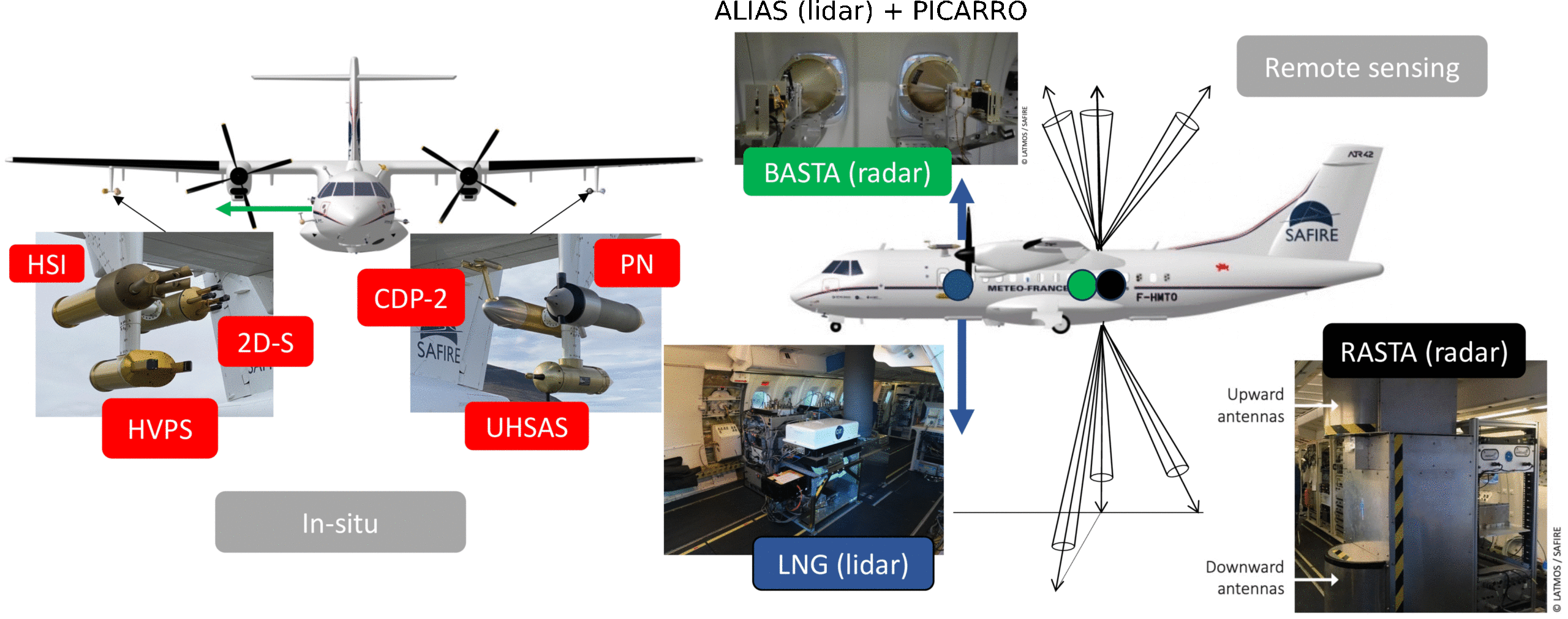
The ATR42 will be deployed with a very large payload including both remote sensing and in-situ measurements of aerosols, clouds and precipitation properties (see figure above). The aircraft will carry the RALI (Radar-lidar) and PMA (Airborne in-situ Measurement Platform) platforms, both labeled “National Instrument Facility” by CNRS-INSU. They will be accompanied by the ALiAS lidar and the water isotope analyzer PICARO. This configuration will allow us to document cloud and precipitation microphysics and dynamics.
| Instruments / Objectives | Aerosols | Clouds precipitation | Wind | Turbulence | Surface | Humidity |
| LNG lidar (UV, 532, 1064 nm) | yes | yes | C/A | C/A | yes | |
| Multiview Doppler cloud radar RASTA (95GHz) | yes | C/P | C/P | yes | ||
| Sideward Doppler cloud radar BASTA (95 GHz) | yes | C/P | C/P | |||
| PMA probes | yes | yes | ||||
| Aircraft baseline information | yes | yes | yes | |||
| CLIMAT, Pyrano- & pyrgeometers | yes | yes | yes | |||
| PICARRO | isotopes | isotopes |
______________________________________________________________________________________________________
Cessna F406 payload
The Cessna F406 is equipped with a nose-boom which incorporates a 100 Hz in-situ turbulence probe (3-D wind vector, temperature, humidity). Thus, the aircraft can perform measurements of the sensible and latent heat flux, as well as the momentum fluxes, inside the boundary layer. Further, the aircraft also carries radiation and surface temperature sensors as well as a VIS camera system, establishing a link between the observed fluxes and the land- or sea-surface characteristics.
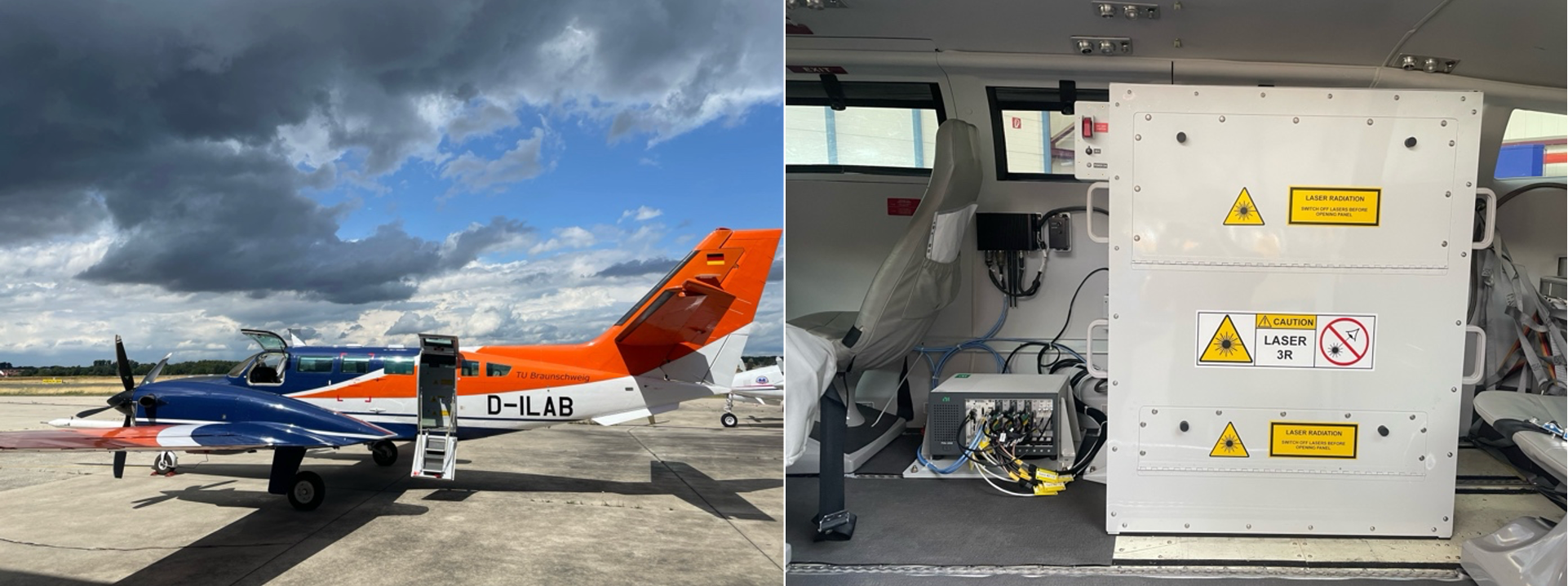
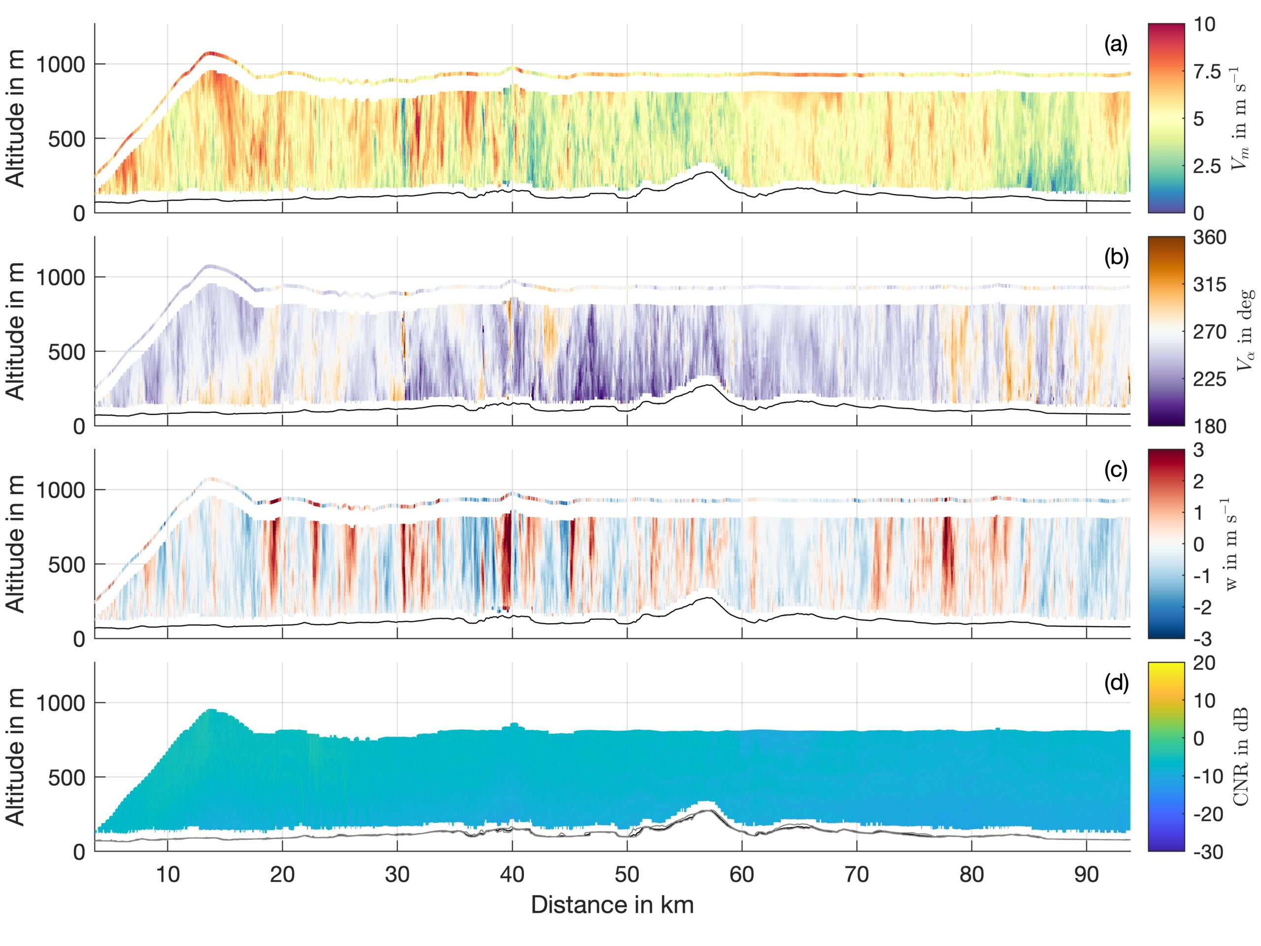
Besides the in-situ turbulence probe the Cessna F406 will carry a novel fixed-beam airborne Doppler lidar (ADL) system, which allows to measure wind below the aircraft at 100 m resolution (https://www.imk-tro.kit.edu/english/12875.php). The novel ADL has been developed at KIT in a project termed AIRflows (AIRborne fixed-beam lidar for wind measurements). Instead of a single Doppler lidar with a scanner, used by all previously existing ADL systems, the new AIRflows system uses five small and lightweight Doppler lidars with fixed beam directions. The simultaneous availability of multiple viewing directions brings advantages: Simulation results and first observations have demonstrated that a multi-lidar system can achieve approximately one order of magnitude improved spatial wind measurement resolution as well as higher accuracy, compared to existing scanning systems.
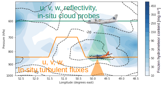
Synchronizing the flight paths of the ATR42 and Cessna F406, with their sophisticated instrumentation on-board, allows us to investigate the relationship between in-cloud dynamics and microphysics and boundary layer conditions such as wind shear, turbulent fluxes and wind variances in unique ways. The measurements will provide detailed insight into the role of wind shear, meso-scale wind features, (evaporating) clouds and differences in surface characteristics on momentum and energy transport during DI situations. Besides improved physical understanding, extensive cross-validation of remote sensing retrievals will become possible due to the synergistic aircraft measurements.